
 WRSAG Stormwater working group reports released Folder
 20230319 WRSAG 29 Issues and Solutions Flood response 20230405 WRSAG Stormwater Group Flooding Report 1 V6 20230407 WRSAG Stormwater Group Flooding Report 1 Summary V6.1 20230409 WRSAG Public Meeting Stormwater Background and Resolutions V3 20230421 WRSAG Stormwater Working Group Precirculation for TCDC Working Group 20230430 Emails WRSAG and TCDC stakeholders meeting master plan 20230430 WRSAG follow up TCDC Stormwater Working Group meeting outcomes 20230504 WRSAG internal discussions Flood Report Whangamata Response 1 20230516 TCDC Whangamata Stormwater Group Action Plan meeting outcomes 20230523 WRSAG Stormwater Group Flood Report 2 v2 20230529 WRSAG Stormwater Group Flooding Report 2 Summary 20230613 WRSAG (Kiwi Rd) To Honourable Len Salt Mayor Kiwi Rd Issues 20231029 WSAG Island View stormwater pond alternate design Ian 20231108 WSAG Island View stormwater detention basin alternate design 20231122 WSAG Proposed DrainMOD modified drainage and recharge stormwater system for Whangamata Holocene Sands 20231202 WSAG 110 Kiwi Road flooding - problem and solutions interim review 20231205 Williamson Park Pond Stormwater Detention Basin Alternate Design 20231211 WSAG Ians meeting notes following workshop 20240222 WSAG Addendum report Williamson Pond following weather event 20240222 WSAG Flooding Event Photos collected 20240226 WSAG Workshop Stormwater Group engagement proposal 20240311 WRSAG Compilied street addresses flooding Whangamata SmartMAPS Opus (2) 20240320 WRSAG Williamson Park Pond Stormwater Detention Basin Alternate Design (2) 20240404 WRSAG Details of spillway construction Williamson Weir 20240407 WRSAG Williamson Pond Beach scour and algae bloom 20240408 WRSAG LTP submission final 20240411 WRSAG Email trail workshops WRC letter wetland to LGOIMA 20240415 WRSAG Investigation into Island View pond and shoreline erosion 20240415 WRSAG Mooloo Crescent Flooding 20240422 WRSAG Draft Open letter to CEO TCDC Stormwater (not sent but discussed) 20240423 WRSAG Complaint to our elected members wetland decision 20240524 WRC LGOIMA Response REQ208325 Williamson Pond 20240527 WRSAG selected LGOIMA email response community involved Wetland and Drybasin WRC 20240528 WRSAG Stormwater Action Group update Williamson Wetland and 20240604 WRSAG Request to Community Board Formal appointment of stakeholders representatives 20240618 WRSAG Whangamata Park CSDC 105667 Discussion Document WRC and TCDC 20240619 WRSAG Perspective on Stormwater Presentation to Rebus 20240701 WRSAG Williamson Drybasin progress report Rain event and comments 20240716 WRSAG presentation CB Independent commissioner Stormwater Group proposal 2005 Opus Stormwater Catchment Management Plan CMP Whangamata 2012 Opus Groundwater Monitoring report Whangamata water tables 2017 Opus Williamson Park Pond Assessment Report Whangamata 20230531_085925 _SC_
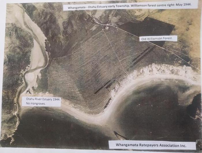 20230531_215938 _SC_
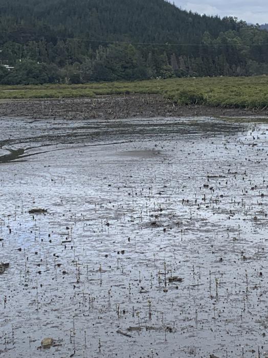 Williamson pond report by Eric

